Saturday, August 13, 2005

Sprites in the night of 11/12 August

Among the last days of thunderstorm activity over France (8-12 Aug) the night of 11/12 August was a success in observing sprites. The observation conditions at Pic du Midi were not very favourable because of high humidity, but Puy de Dôme was better this time. From Thursday evening to late night hours two thunderstorm systems over the south-east of France and northern Italy remained active. They produced lots of electric discharges, and at least some of them apparently produced sprites. The system of Puy de Dôme recorded two carrot sprites. The first was captured at about 22:44:16 UT (11 Aug):


The second event was captured 16 min later at about 23:02:21 UT:


with longer lasting luminous cores:


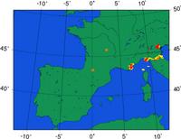
The maps of the cloud-to-ground discharges detected by Meteorage during a 5-min period when the sprites happened show many smaller positive and negative discharges. None of them, however, is close to the occurrence of these sprites:


At 23:12:39 UT a third sprite was detected:

Friday, August 12, 2005

Thunderstorm Outlook: Fri 12 - Wed 17 Aug

It is time for a long-term outlook update again. Currently, unstable airmass is quite far over Italy and the Balkan, as well as the Benelux and Germany. Over Spain some isolated thunderstorms are also still possible. However, nothing looks quite impressive at the moment. During the weekend, destabilization will take place over the Iberian Peninsula at the approach of a weak upper low, and more widespread storms will be occurring there. After the weekend the unstable airmass may slowly expand northward if the high pressure area over northwestern Europe starts to weaken. Overall it looks like there will be some chance to observe thunderstorms the coming days, but it isn't a powerful setup.

Thursday, August 11, 2005

ULF and ELF electromagnetic measurements in TLEs research

At this moment we are waiting for more chances to observe sprites or elves – any Transient Luminous Events (TLEs). Having already observed some one can think about using them with other measurements to extend the TLEs-related scientific studies. One of the important possibilities is to compare the optical observations with measurements of electromagnetic field in the Ultra Low Frequency range and Extremely Low Frequency range (0.003 Hz – 3000 Hz).

Thunderstorm discharges generate electromagnetic radiation over a wide spectrum, with the maximum in the ULF/ELF range. It can be observed in electromagnetically quiet places on the globe. The large discharges, that usually accompany sprites (parent-lightnings), produce electromagnetic signals, usually of high amplitude and specific shape, and cause characteristic ULF/ELF events. This is also believed to be the case for some sprites and elves. Thus the simultaneous observations of both would be very useful. By use of these measurements we can learn more about:

  • What are the connections between the sources and the produced electromagnetic signals?
  • How these signals propagate in the environment?

Besides the CAL research groups, which are especially involved in TLEs research, other scientific groups have already become interested in contribution with their measurements and efforts to study the related phenomena in the ULF, ELF, VLF ranges and beyond.

This web site provides more links and details on some electromagnetic ULF/ELF phenomena, measurements, and the role of ULF/ELF measurements in TLEs-related studies.

Wednesday, August 10, 2005

Thunderstorm Outlook: Wed 10 Aug


Tonight has all ingredients to support a major round of storms over northeastern Spain and southern France and part of the northwestern Mediterranean Sea. Storms have already developed, let's hope they cluster later tonight into a nice mesoscale convective complex. Hopefully the view of our cameras will become clear before the storms start to produce sprites, if any! Wish our camera operators of tonight - Anna & Agnes - good luck!

Sunday, August 07, 2005

Thunderstorm Outlook: Sun 7 - Thu 11 August

Seems like we don't have to wait as long as models indicated earlier: finally there will be new chances for thunderstorms to occur in our observation area this week, as low pressure develops over southwestern Europe. As usual, chances of larger nocturnal storms get better with time. Sunday night there is a slight chance of some thunderstorms over Spain, which probably don't last into the night. Monday night the chances are better, and the Pyrenees probably trigger some storms as well. Tuesday night seems to be a more serious night with storms reaching into northern Spain and southwestern France, and Wednesday night instability will have been advected into a larger portion of France, with widespread thunderstorms possible. If all of this comes true, Thursday night will be the last to feature thunderstorms at close range.